
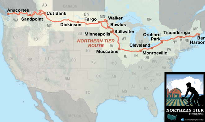
The Adventure Cycling Association is a bicycle touring advocacy group that maps a number of bike routes around the country. My cross country ride will follow the Northern Tier which starts in Anacortes, Washington and ends in Bar Harbor, Maine, 4,300 miles later. I will ride a slightly modified route starting about thirty miles south on Camano Island where we have friends with a beach house. Rather than finishing in Bar Harbor I prefer to ride directly home to Danbury, Connecticut. The official route follows the Erie Canal trail east of Buffalo, New York for while before veering north into the Adirondacks then east to Vermont, New Hampshire and finally Maine. My plan is to stay on the Erie Canal to Albany, NY then head south to home. The route south of Albany will follow part of the Empire State Trail, New York states 750 miles of rail trail and road trails linking New York City north to Canada and Albany west to Buffalo. The Maybrook and Dutches County rail trails are part of this network connecting New Paltz, NY to Brewster, NY, where I rode many miles training for this ride.
I haven’t spent much time planning mid route options. With the Canadian border still closed I probably will not ride the Glacier National Park alternative route. There are a few other alternative routes along the way that need to be sorted out as they get closer. My modified route should be about 3,800 miles.
For navigation I will use digital maps on the Bicycle Route Navigator app by the ACA. I also bought the old school paper maps which are very informative plus technology always fails at the worse possible time. The paper maps split the route into 11 maps with descriptions of the area, services available along the way and enlarged tiles for about every 50 miles.

